
Robben Island
The Story of an Island in the Bay
Discover Robben Island, a historic isle 6.9 kilometers west of Bloubergstrand in South Africa, named after the Dutch word for seals, "robben." Spanning 5.08 square kilometers, the flat island witnessed centuries of erosion. Once a fortified prison from the late 17th century until apartheid's end in 1996, Robben Island is now a symbol of resilience and liberation. Take a ferry from V&A Waterfront for a unique journey intertwining nature and history. Explore the island's museum and guided prison tour to connect with South Africa's impactful history, celebrating the triumph of the human spirit.

Vistors Information
Times
Peak Season - 01September - 30 April
Departure times
09:00
11:00
13:00
15:00
Off - Peak Season - 01 May - 30 August
Departure times
09:00
11:00
13:00
a Brief History and Overview
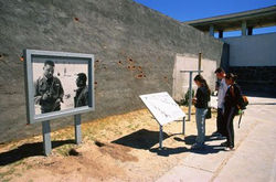
Robben Island, located 11 km from Cape Town at the entrance to Table Bay, has a rich history dating back to its discovery by Bartolomeu Dias in 1488. Initially used as a refueling station by Portuguese, English, and Dutch navigators, the island later became a multifaceted site. From housing Dutch settlers' livestock in 1654 to serving as a prison for political leaders, including early inhabitants like Autshumato and those from Dutch colonies, Robben Island witnessed various roles. Over the years, it functioned as a leper colony, animal quarantine station, and a whaling station established by Scottish whaler John Murray in 1806. Following the end of apartheid, the island transformed into a significant tourist destination, managed by the Robben Island Museum. Declared a World Heritage Site in 1999, the island welcomes visitors through tours departing from Cape Town's waterfront, offering insights into its historical sites, including the former maximum-security prison where Nelson Mandela was incarcerated. The treacherous surrounding waters also hold a maritime history with numerous shipwrecks, showcasing the challenges faced by seafarers navigating near Robben Island over the centuries.
Directions and Map
Head south on W Coast Rd/R27
Continue to follow R27
24.9 km
Keep left to continue on Marine Dr/R27
500 m
Merge onto F W de Klerk Blvd/N1
1.3 km
Keep right to continue on N1, follow signs for Sea Point/Waterfront
Turn right onto Walter Sisulu Ave
110 m
Continue onto Dock Rd
300 m
Continue straight onto S Arm Rd
350 m
At the roundabout, continue straight to stay on S Arm Rd
56 m
Turn left onto Fish Quay
 |  |  |  |  |  |
|---|---|---|---|---|---|
 |  |